Snow
Somewhere down the lane, a licky boom boom down
SW-Iceland has had a lot of small earthquakes in January and as usual everything is closely monitored.
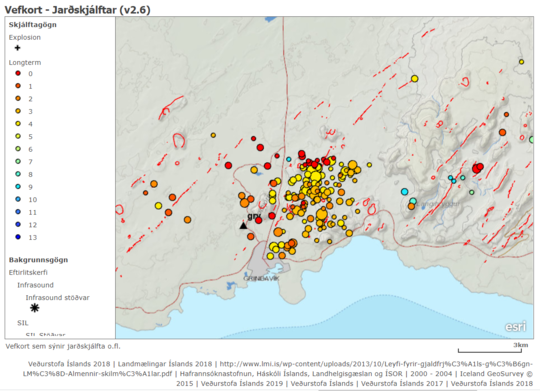 As you can see there's a decent amount of them but the red dots is not something you notice. The largest ones were 3.6 and 3.7 and could be sensed in the town of Borgarnes which is 120km North. The black triangle shows the position of the earthquake station monitor.
Many of you are familiar with the Blue Lagoon. Below is a picture of land uplift as seen from satellite. This picture is why scientist are worried because although multiple earthquakes aren't uncommon for this area, land uplift is not. Right in the middle of the red area is a mountain and the Blue Lagoon is right next to it. Grindavík is on the edge of the red circle.The image shows how much land uplift has happened between the 18-24th of January. Red area is more than 15mm and in total the land has risen more than 2cm in that area. That heavily suggest that there's a lot of lava activity beneath. Last time lava erupted in this area was inn 1210-1240, 3 in total and all of them magmatic eruptions (like in Hawaii) which means lava will flow up from cracks in the range from a few kilometers in length to tens of kilometers.
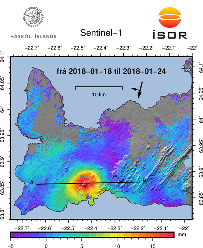
There's now a yellow alert at Keflavík International airport (~25km from Grindavík) which means that volcanic activity is being monitored and the airport and people close by need to pay attention.
These things can move very slowly and there's really no saying if anything is going to happen or if something happens what the magnitude of it will be. Our National Weather Service has said that these are the possible outcomes:
If land uprising is caused by lava collecting:
I'm not familiar with geological terms in English since this is pretty much the only academic subject (besides Icelandic) where all of the source material is Icelandic and therefor we've made the terms up rather than translate them.
Many of you are familiar with the Blue Lagoon. Below is a picture of land uplift as seen from satellite. This picture is why scientist are worried because although multiple earthquakes aren't uncommon for this area, land uplift is not. Right in the middle of the red area is a mountain and the Blue Lagoon is right next to it. Grindavík is on the edge of the red circle.The image shows how much land uplift has happened between the 18-24th of January. Red area is more than 15mm and in total the land has risen more than 2cm in that area. That heavily suggest that there's a lot of lava activity beneath. Last time lava erupted in this area was inn 1210-1240, 3 in total and all of them magmatic eruptions (like in Hawaii) which means lava will flow up from cracks in the range from a few kilometers in length to tens of kilometers.
There's now a yellow alert at Keflavík International airport (~25km from Grindavík) which means that volcanic activity is being monitored and the airport and people close by need to pay attention.
These things can move very slowly and there's really no saying if anything is going to happen or if something happens what the magnitude of it will be. Our National Weather Service has said that these are the possible outcomes:
If land uprising is caused by lava collecting:
- Lava collection stops without any other event happening
- Lava collection continues at the same place at the same pace for some time without further events happening
- Lava collection continues and leads to fissure vents
- Lava collection continues and leads to fissure vents and volcanic eruption
- Lava collection causes increased earthquake activity with larger earthquakes (up to 6.0)
- Land uprising could cause increased earthquake activity and larger earthquakes (up to M6)
I'm not familiar with geological terms in English since this is pretty much the only academic subject (besides Icelandic) where all of the source material is Icelandic and therefor we've made the terms up rather than translate them.